


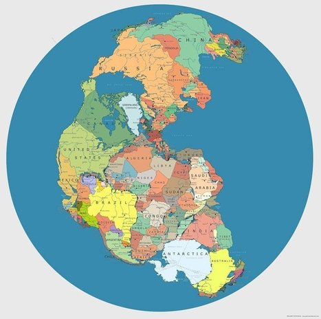
When I discuss environmental geography in my Introduction to Geography course, I begin with a discussion of the history though on nature, civilization and culture. I've shown pictures of the natur...
Get Started for FREE
Sign up with Facebook Sign up with X
I don't have a Facebook or a X account


 Your new post is loading...
 Your new post is loading...
Your new post is loading...
When I discuss environmental geography in my Introduction to Geography course, I begin with a discussion of the history though on nature, civilization and culture. I've shown pictures of the natur...
Geography Teachers' Association of Victoria Inc. (GTAV)'s insight:
Lots of great information and links her if you are interested in learning how to make StoryMaps 
Geography Teachers' Association of Victoria Inc. (GTAV)'s insight:
Try to find the location seen in the picture in the upper right within the fixed number of guesses. Warning highly addictive - guaranteed to suck you in!!
Geography Teachers' Association of Victoria Inc. (GTAV)'s insight:
Thousands of never-before-seen data products from the US Landsat satellites acquired over 30 years have been released for online access. In addition, the newest data over Europe from the latest satellite in the series, Landsat-8, are now accessible in near-real time through a new portal hosted by ESA. About 150 000 new products from the Landsat-5 satellite are available for direct download, free of charge. The products from the satellite’s Thematic Mapper instrument were acquired by the Kiruna ground station in northern Sweden between 1983 and 2011. ESA recently completed reprocessing the data at a higher quality than ever before. The products are now aligned with those from the Landsat-8 satellite, paving the way for ESA’s provision of data from the latest satellite in the series.
Geography Teachers' Association of Victoria Inc. (GTAV)'s insight:
PowToon is a brand new presentation tool that allows you to create animated presentations and cartoon style videos just by dragging and dropping.
Geography Teachers' Association of Victoria Inc. (GTAV)'s insight:
Let me introduce you to a new bio-optical knowledge recording and dissemination system, responding to the trade name : MAP.
Love this!

Wild fires of Canada and Indonesia, sand storms and steam spewing volcanoes were among the images captured by European Space Agency and Nasa satellites last month
Geography Teachers' Association of Victoria Inc. (GTAV)'s insight:
This gallery of 20 satellite images is truly stunning...there are some great teaching images in there.
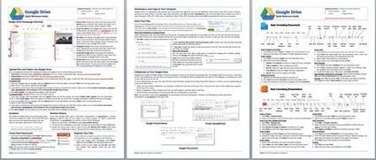
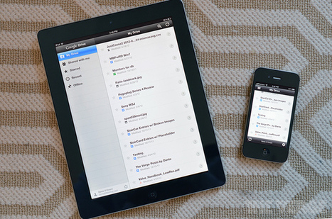
Having trouble getting your head around Google Drive and / or Google Docs?

Dr Sarah Parcak uses satellite technology to unearth Egypt's ancient settlements, pyramids and palaces lost in the sands of time.
Geography Teachers' Association of Victoria Inc. (GTAV)'s insight:
The use of Geospatial Technologies in other disciplines.

"These jarring moments expose how Google Earth works, focusing our attention on the software. They reveal a new model of representation: not through indexical photographs but through automated data collection from a myriad of different sources constantly updated and endlessly combined to create a seamless illusion; Google Earth is a database disguised as a photographic representation. These uncanny images focus our attention on that process itself, and the network of algorithms, computers, storage systems, automated cameras, maps, pilots, engineers, photographers, surveyors and map-makers that generate them.”

Gregory S Sankey Jr.'s curator insight,
September 12, 2013 9:55 AM
I understand that this article mostly depicts the inherent limitations with our current technology within GIS systems but I mostly just found these images to be eerily and awkwardly beautiful. Art made accidentely. Thank-you flawed technology. 
How To Create A Paperless Classroom With Your iPad

Amazing 360° aerial panoramas for a fully interactive aerial experience. As close as you'll get to flying, without leaving the comfort of you chair. Experience them for youself!
Geography Teachers' Association of Victoria Inc. (GTAV)'s insight:
As Geographers I think we could 'get lost' in these images !! Check out the 360 Panoramas. Simply stunning.
Geography Teachers' Association of Victoria Inc. (GTAV)'s insight:
These images were created when 'Aral Sea' was put into the search box. Enter any location and 1975 and 2000 will be displayed.
|
Geography Teachers' Association of Victoria Inc. (GTAV)'s insight:
As iPads proliferate in schools around the world, and students as well as teachers create more and more content, questions about what to do with all of those learning objects have arisen.

With Google Earth's sliding time-lapse tool, you'll see the shocking effects of bustling development, natural disasters, explosions and terror attacks.
Geography Teachers' Association of Victoria Inc. (GTAV)'s insight:
Queensland Globe is an innovative online tool which allows users to view and explore spatial data about Queensland using the Google Earth application.
Geography Teachers' Association of Victoria Inc. (GTAV)'s insight:
Maki is a clean point of interest icon set made for web cartography. It includes 95 different symbols at 3sizes each for a total of 285 icons and growing.
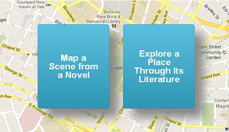
Go behind the scenes of a new site based in Google Maps that combines geography, technology, and literature into a crowdsourced map of real locations from novels. Read this article by Amanda Kooser on CNET.
Geography Teachers' Association of Victoria Inc. (GTAV)'s insight:
The use of Geospatial Technologies in other disciplines.
Geography Teachers' Association of Victoria Inc. (GTAV)'s insight:
Although 75% of the planet is a relatively unchanging ocean of blue, the remaining 25% of Earth's surface is a dynamic green. Data from the NASA/NOAA Suomi NPP satellite is able to detect these subtle differences in greenness. The resources on this page highlight our ever-changing planet, using highly detailed vegetation index data from the satellite, developed by scientists at NOAA. The darkest green areas are the lushest in vegetation, while the pale colors are sparse in vegetation cover either due to snow, drought, rock, or urban areas. Satellite data from April 2012 to April 2013 was used to generate these animations and images.
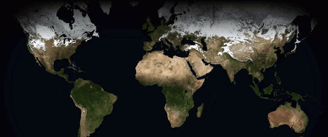
Spring comes, then summer, fall and winter and if you are off the planet with a camera looking down at Earth, the seasons seem like breaths. Speed up the imagery, and the planet seems to pulse, like a living thing.

Some city skylines are so iconic they are instantly recognisable. Leaving out the most obvious contenders, we've put together this gallery of cities around the world – see how many you can guess
Geography Teachers' Association of Victoria Inc. (GTAV)'s insight:
Something for more senior students at the end of last lesson on a Friday or as an end of term activity?? Not as straight forward as you'd think as the cities used are not the obvious ones like New York, Paris etc.
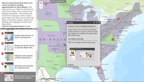
"Did you know know that there are some excellent reading opportunities in Story Maps? This map serves as a table of contents for using Story Maps with Common Core Reading Standards. Reinventing the wheel isn't necessary with so many great maps and data sources that will help us teaching reading, writing and thinking with engaging content and little effort."
If you're a visual learner then you know maps, charts and infographics can really help bring data and information to life. Maps can make a point resonate with readers and this collections aims to do just that!
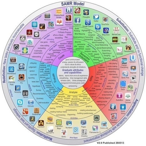
Good friend and mentor Allan Carrington recently enhanced his "Padagogy Wheel" a visual representation of how iPad apps can be integrated into learning experiences using Bloom's Taxonomy. Via John Evans

Marilyn Korhonen's curator insight,
June 21, 2013 10:34 AM
Teaching and learning become so complex as more and more tools are added in the context of stricter and stricter standards and assessments. 
James I.'s curator insight,
August 20, 2014 9:57 AM
Bloom's Wheel with iPad apps including SAMR model
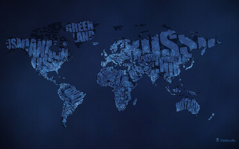
Geography Teachers' Association of Victoria Inc. (GTAV)'s insight:
Typographic World Map, with night colours and city lights, inspired by Earth at Night by NASA
|


Lots of great information and links her if you are interested in learning how to make StoryMaps